
Vulcan Minerals Inc. - Colchester Copper-Gold Update in Central Newfoundland
ST. JOHN 'S, NL / ACCESS Newswire / November 13, 2025 /Vulcan Minerals Inc. ( "the Company " - "Vulcan ") (TSXV:VUL),provides an update on the Colchester project with a review of historical drilling and compilation incorporating the most recent drilling results. A compilation of historic drilling highlights for the Colchester project includes up to 39.97 meters of 1.03% copper and 15.8 meters of 2.19% copper. A property review is also presented including the Little Bay project.
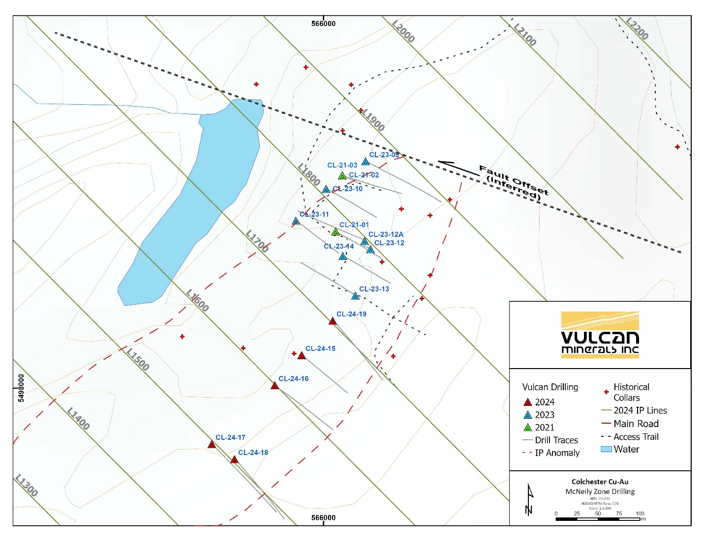
The McNeily drill program (part of the Colchester Project) carried out in late 2024 is reviewed and incorporated into the compilation. Highlights are as follows:
5.2 meters of 1.01% copper in hole CL-24-19 within a wider 13.7 meters of 0.48% copper
2.5 meters of 1.26% copper in hole CL-24-17
5.3 meters of 0.52% copper and 0.91 grams per tonne gold including 0.4m of 0.78% copper and 5.02 grams per tonne gold in hole CL-24-18
A total of 718 meters (m) were drilled over 5 holes designed to test Induced Polarization (IP) anomalies from the 2024 survey and expand the known volcanic massive sulphide copper-gold mineralization to the southwest of previous drilling. The program has extended mineralization 150 meters southwest of historic drilling for an overall zone strike length of approximately 450 meters which remains open.
Stringer disseminated and locally semi-massive sulfide zones were encountered containing chalcopyrite with variable associations of pyrite, pyrrhotite and minor sphalerite. Mineralization is associated with chalcopyrite within sheared and chloritized mafic volcanic rocks.
The drill program successfully tested the potential eastern limits of the McNeily zone south of hole CL-23-13 (Vulcan 2023 hole) which returned the following results:
HOLE ID | From (m) | To (m) | Length (m) | Type | Cu % | Au g/t | ||||||||||
CL-23-13 | 8 | 23 | 15 | Composite | 1.21 | 0.51 | ||||||||||
Including | 11 | 17.75 | 6.75 | Composite | 2.38 | 1.01 |
CL-24-17
Hole CL-24-17 was drilled to a length of 173m and targeted the eastern flank of the southern IP anomaly. Chalcopyrite is present as stringers and semi-massive zones within intense chlorite altered shear zones. Notable intersections include a 1m sample containing 3.25 g/t Au and an interval averaging 4.55m of 0.85% Cu with 0.5 g/t Au including 2.5m containing 1.26% Cu and 0.41 Au.
HOLE ID | From (m) | To (m) | Length (m) | Type | Cu % | Au g/t |
CL-24-17 | 116.65 | 120 | 3.35 | Composite | 0.77 | 0.24 |
CL-24-17 | 126.5 | 127.5 | 1 | Sample | 0.03 | 3.25 |
CL-24-17 | 139.25 | 143.8 | 4.55 | Composite | 0.85 | 0.50 |
Including | 139.25 | 141.75 | 2.5 | Composite | 1.26 | 0.41 |
CL-24-18
CL-24-18 was drilled approximately 50m southeast of CL-24-17 to a length of 140m. This hole was designed to test the vertical extent of mineralization encountered in CL-24-17. Chalcopyrite is present as stringers and semi-massive zones within intense chlorite alteration. Significant results include 5.3m of 0.52% Cu and 0.91 g/t Au, a 0.4m sample containing 0.78% Cu and 5.02 g/t Au, as well as a 9m section averaging 0.86 g/t Au including 3m of 1.25 g/t Au.
HOLE ID | From (m) | To (m) | Length (m) | Type | Cu % | Au g/t |
CL-24-18 | 51.5 | 56.8 | 5.3 | Composite | 0.52 | 0.91 |
CL-24-18 | 60 | 60.4 | 0.4 | Sample | 0.78 | 5.02 |
CL-24-18 | 85 | 94 | 9 | Composite | 0.06 | 0.86 |
Including | 85 | 88 | 3 | Composite | 0.14 | 1.25 |
CL-24-19
Hole CL-24-19 was drilled between CL-24-15 and CL-23-13 to a length of 143m. This hole targeted a potential offset of the zone to the southeast. Drilling encountered abundant chalcopyrite stringer zones associated with chloritized shear zones and faults. Significant intersections contained 13.7m of 0.48% Cu, including 5.2m of 1.01% Cu.
HOLE ID | From (m) | To (m) | Length (m) | Type | Cu % | Au g/t |
CL-24-19 | 91.2 | 104.9 | 13.7 | Composite | 0.48 | 0.05 |
Including | 91.2 | 96.4 | 5.2 | Composite | 1.01 | 0.06 |
CL-24-15 and Cl-24-16
These holes encounteredzones of shearing, chlorite alteration and sulfides as pyrite with minor chalcopyrite in stringers. Discontinuous lower grade (less than 0.4%) copper and anomalous gold grades were encountered over a gross interval from 68.5m to 84.5m length in CL-24-15 and over a gross interval from 90.9m to 123m length in CL-24-16.
Notes:
True widths are uncertain but are interpreted to be close to drilled thicknesses, though more drilling is required to confirm the exact orientation of the mineralized zones. The tables summarize composited assay intervals described for the reported holes. These intervals are length-weighted averages of core-thickness intervals. Only assayed intervals were included in the composites. A total of 270 samples were cut and submitted for assay. Significant assays are reported herein, remaining samples represent lower grade sampling in envelopes around the mineralized zones and additional samples without significant mineralization taken for stratigraphic-correlation purposes.
Drill Hole Coordinates:
HOLE ID | East | North | Azimuth | Dip | Length |
CL-24-15 | 565974 | 5498040 | 135 | -60 | 128 |
CL-24-16 | 565942 | 5498004 | 135 | -50 | 134 |
CL-24-17 | 565867 | 5497934 | 135 | -50 | 173 |
CL-24-18 | 565894 | 5497916 | 135 | -50 | 140 |
CL-24-19 | 566011 | 5498081 | 135 | -50 | 143 |
Coordinates are UTM NAD83 Zone 21
President Patrick Laracy notes "The McNeily zone is proving to have continuity along strike as expressed by the related IP anomaly. The drill program was designed as reconnaissance testing of the anomaly. Given its length (700m) and width (200 to 300 meters) the anomalous zone will require systematic drilling of multiple holes across its width to accurately locate the main causative chargeability source and the nature of the associated mineralization. High-grade copper intersections with appreciable gold credits continue to warrant further delineation towards adding tonnage to the overall Colchester project. "
The Company acknowledges the financial support for the drilling campaign from the Junior Exploration Assistance Program by the Government of Newfoundland and Labrador.
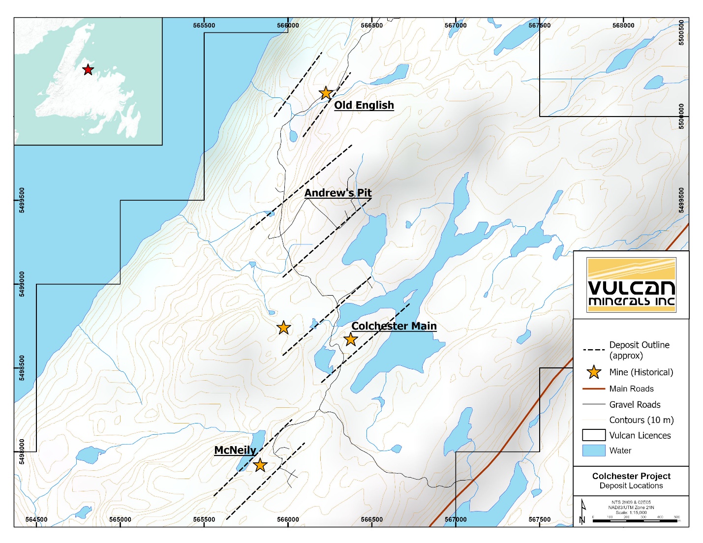
The Colchester project is part of the larger Springdale property which hosts numerous historic copper and gold deposits and showings, none of which have been adequately explored with the benefit of modern digital geophysical and geological modelling. These prospects occur within close proximity to each other and provide excellent advanced exploration targets towards resource definition. The Springdale property is road accessible and near significant mining services.
Historic Compilation and Context
Property Location, Access & Land Position
The Colchester project is 100% owned by Vulcan and consists of 72 claims covering 1,800 hectares out of Vulcan 's larger, regional-scale Springdale property in west-central Newfoundland, which comprises 273 claims over 6,825 ha. The Colchester project is the flagship of the Springdale property, which includes several additional copper-gold exploration targets. The project is in long term good standing with respect to regulatory work assessment requirements because of the Company 's ongoing exploration activities.
Colchester is accessible by paved road approximately 25 kilometers off the Trans Canada Highway, with woods roads connecting several zones within the project. The provincial electrical grid borders the eastern edge of the property. The property is accessible for exploration work year-round.
Several nearby communities such as Springdale and Kings Point host exploration and mining service providers who are actively involved in the current resurgence in gold and base metal exploration in central Newfoundland. These include Firefly Metals Ltd. 's development work at the Rambler-Ming mines (copper-gold) on the Baie Verte peninsula and Maritime Resources Corp. 's revitalized Hammerdown Gold project where the first pour of gold just occurred (approximately 5 km south of the Colchester project claim boundary). Drilling companies are based out of Springdale, providing for competitive drilling rates and efficient logistical operations.
Historical Highlights
Vulcan has compiled an extensive dataset of historical exploration and mining activities on the Colchester project. This includes the digitization of surface sampling (rock, soil, till, stream, heavy mineral concentrates), bedrock and trench mapping, diamond drilling (survey, lithological and assay data), ground and airborne geophysical surveys (VLF, EM, IP, magnetics and gravity). Vulcan has added value to this project with its modern dataset, including prospecting, bedrock mapping, high-resolution 3D IP surveying and diamond drilling. Thus, the project has an extensive digitized dataset with serious potential for leverage.
The Colchester project is host to multiple copper-gold deposits including five of the nine historical mine sites in the immediate region, most of which were mined at a very limited scale from 1881 to 1901. Outside the Colchester project, mining occurred at Little Bay (a Vulcan property), the Whalesback and Little Deer mines at varying times in the 1960 's into the early 1970 's.
The Colchester project was explored historically for copper, however, significant historic gold occurrences have been identified at surface and in drilling at multiple zones notwithstanding that gold was not regularly assayed at the time. At the Old English Zone, 4.18 g/t gold was drilled over 2.90m and at the Main Zone 5.86 g/t gold was drilled over 3.85m.
Modern exploration commenced in the 1960 's in the area of the "Colchester Main Zone " resulting in a 1967 historical resource estimate of 1,000,000 tons of 1.3% copper at a cut-off grade of 0.85% copper (non-compliant with modern NI 43-101 requirements); gold was not included in that resource estimate because it had not been systematically assayed. Vulcan 's 3D modelling of historical drilling data demonstrates that the footprint of the drilling included in the 1967 resource estimate comprises only 30-40% of the current extent of drilling at the Main Zone, which had received intermittent attention until the mid-2000 's.
Historically, explorers drilled coincident copper soil and geophysical anomalies, both magnetic and IP, which proved to be a successful exploration method and was the primary driver in the discovery and expansion of the known mineralized zones. Modern geophysical techniques have increased the resolution, extent and depth of these anomalies. However, many other areas with surface mineralization remain untested.
The Company has compiled and digitized the following data base derived from government filed assessment reports by previous operators.
Colchester Compilation Stats
Reports | Geophysical Surveys | DD Holes | Meters | Core Samples | Geochemical Soils | Surface Rocks |
51 | 15 | 110 | 21994 | 2979 | 3378 | 1103 |
Selected highlights from historic drilling for copper are listed below. They are intended to demonstrate the copper potential of the Colchester project.
Hole-ID | Zone | From | To | Length | Composited |
436-11 | McNeilly | 86.28 | 90.83 | 4.55 | 4.55 m @ 3.82% |
436-16 | Main Zone | 142.30 | 157.60 | 15.30 | 15.30 m @ 1.02% |
436-16 | Main Zone | 167.94 | 178.13 | 10.19 | 10.19 m @ 1.07% |
436-21 | Main Zone | 23.96 | 38.10 | 14.14 | 14.14 m @ 1.95% |
436-21 | Main Zone | 53.04 | 71.63 | 18.59 | 18.59 m @ 1.61% |
436-21 | Main Zone | 53.04 | 73.10 | 20.06 | 20.06 m @ 1.51% |
436-30 | Main Zone | 59.74 | 69.98 | 10.24 | 10.24 m @ 2.20% |
436-37 | Main Zone | 46.02 | 57.21 | 11.19 | 11.19 m @ 1.33% |
436-38 | Main Zone | 183.28 | 193.55 | 10.27 | 10.27 m @ 1.16% |
436-39 | Main Zone | 178.61 | 192.27 | 13.66 | 13.66 m @ 1.01% |
436-41 | Main Zone | 128.96 | 155.45 | 26.49 | 26.49 m @ 1.43% |
436-6 | Main Zone | 106.68 | 131.06 | 24.38 | 24.38 m @ 1.21% |
436-8 | Main Zone | 119.09 | 131.98 | 12.89 | 12.89 m @ 1.32% |
CC-03-02 | Main Zone | 74.20 | 90.00 | 15.80 | 15.80 m @ 2.19% |
CC-03-11 | McNeilly | 72.85 | 84.00 | 11.15 | 11.15 m @ 1.68% |
H-48 | Main Zone | 322.78 | 346.01 | 23.31 | 23.31 m @ 1.24% |
H-49 | Main Zone | 187.45 | 203.61 | 16.16 | 16.16 m @ 1.68% |
H-51 | Main Zone | 70.10 | 82.60 | 12.50 | 12.50 m @ 2.49% |
H-51 | Main Zone | 160.02 | 192.63 | 32.61 | 32.61 m @ 1.04% |
H-52 | Main Zone | 146.91 | 172.21 | 25.30 | 25.30 m @ 1.02% |
H-61 | McNeilly | 69.34 | 82.30 | 12.96 | 12.96 m @ 1.97% |
H-69 | Main Zone | 192.02 | 202.69 | 10.67 | 10.67 m @ 1.27% |
H-78 | Old English | 96.62 | 132.59 | 35.97 | 35.97 m @ 1.03% |
*OE-16-01 | Old English | 48.52 | 53.62 | 5.15 | 5.15 m @ 1.60% |
*OE-16-01 | Old English | 170.64 | 176.63 | 5.99 | 5.99 m @ 1.01% |
*OE-16-03 | Old English | 76.73 | 84.18 | 7.45 | 7.45 m @ 1.02% |
*CL-21-01 | McNeily | 88.00 | 116.00 | 28.00 | 28.0 m @ 1.58% |
*CL-21-01 | McNeily | 102.00 | 116.00 | 14.00 | 14.0 m @ 2.31% |
*CL-23-13 | McNeily | 8.00 | 23.00 | 15.00 | 15.0 m @ 1.21% |
*CL-23-14 | McNeily | 48.5 | 62.00 | 13.5 | 13.5 m @ 1.51% |
*CL-23-14 | McNeily | 48.5 | 56.00 | 7.50 | 7.5 m @ 2.49% |
* Vulcan drill holes.
Selected composited copper drilling grades from Colchester zones; many intersections contain higher-grade subsections not summarized in this table.
Little Bay Mine Property
The Little Bay copper-gold property in north-central Newfoundland is approximately 10 kilometers southeast of the Colchester project. The property consists of 19 claims (475 hectares) covering the past producing Little Bay and Sleepy Hollow mines. These mines operated from 1961-1969. The Little Bay mine produced 2,850,000 tonnes at grades ranging from 0.89% to 1.96% copper and 6,300 ounces gold. In the later stages of production, the Sleepy Hollow mine produced 700,000 tonnes at a grade of 1.5% copper.
The company has compiled 166 drill holes, various geophysical surveys, geochemical surveys and mining reports which have been incorporated into 3D modelling software. The company believes that the mine area has the potential to contain unmined resources based on the geophysical features occurring along strike of the mine workings and the fact the mine closed due to an operational issue with the collapse of the crown pillar.
Vulcan has compiled an extensive digital dataset including mining and production models, exploratory drilling, surficial sampling and geophysical surveys. This is the first fully digital dataset allowing for the integration of various vintages of information which will facilitate a better understanding of the mineralization on the property. Historical activity generally focused on mine workings with relatively little local exploration. The remaining copper resources at both mines, if any, has not been determined. Further work is required to evaluate the complete data set to determine what copper resources may remain in the old workings and to evaluate the potential for extensions of the mineralization outside historic workings.
The Little Bay property is adjacent to claims owned by another operator containing the past producing Whalesback and Little Deer copper mines which are geologically similar to the Little Bay mine. Whalesback is approximately 2 km from the Little Bay claim boundary while Little Deer is approximately 3.2 km from the claim boundary along favourable structural trends. Whalesback produced 3,790,000 tonnes at approximately 1% copper (1965-1971) and the Little Deer mine produced approximately 75,000 tonnes at approximately 2% copper before depressed market conditions forced closure of the mines. Please refer to our webpage www.vulcanminerals.ca for location and general geology maps.
The historical information regarding the Colchester and Little Bay properties and production histories of adjacent mines is taken from assessment reports filed with and compilations by the Government of Newfoundland and Labrador as archived in the Mineral Occurrence Data System (MODS).
Strategy to Realize Value of these Projects
Given the fortunate endowment of mineralization on these projects, it will require significant investment for their advancement, including modern mineral resource evaluations, deposit delineation, confirmation drilling, potential expansion and advanced exploration of several early-stage mineral showings. To this end, the Company will be soliciting partners with the financial strength and expertise to carry out this work.
President Patrick Laracy commented, "We acquired this project as an ' 'option " on higher copper and gold prices anticipating that high-grade resources, with near surface accessibility and local infrastructure would be valuable as relatively quick potential developments compared to larger bulk tonnage copper porphyry deposits. In the interim, we continued to add value to the project through strategic exploration ventures and will continue to do as we solicit partners for the project. In addition to our projects, the Springdale Peninsula has several historic copper-gold deposits providing the potential for a revitalization of advanced exploration and mine development in the region. "
Quality Control
Vulcan used SGS Natural Resources (SGS) for all sample assaying in the drilling program reported herein. SGS Natural Resources analytical laboratories operate under a Quality Management System that complies with ISO/IEC 17025. Vulcan employed SGS ' four-acid digestion / ICP-OES multi-element analysis package grouped with 30g, fire assay, AAS finish for gold. A four-acid digestion / ICP-OES "ore-grade " analysis package is utilized for base metals assaying greater than detection limits. Vulcan employed the use of standard reference materials for quality control at a rate of 5% of total samples. SGS undertakes their own internal coarse and pulp duplicate analysis to ensure proper sample preparation and equipment calibration. Preliminary inspection of these control samples shows them to be within the expected limits.
About Vulcan
Vulcan Minerals is a precious and base metals exploration company based in St. John 's Newfoundland. The company has strategic land positions in multiple active Newfoundland gold and base metal exploration and development belts. It also holds approximately 27% of the shares in Atlas Salt Inc. (TSXV: SALT). Atlas Salt is an industrial minerals company that is currently developing the Great Atlantic Salt mine in western Newfoundland.
Patrick J. Laracy P.Geo., President is the qualified person responsible for the technical contents of this news release as defined in National Instrument 43-101.
We seek safe harbour.
Neither the TSX Venture Exchange nor its Regulation Services Provider, (as the term is defined in the Policies of the TSX Venture Exchange) accepts responsibility for the adequacy or accuracy of this release. This press release includes certain "forward-looking information " and "forward-looking statements " (collectively "forward-looking statements ") within the meaning of applicable Canadian securities legislation. All statements, other than statements of historical fact, included herein, without limitation, statements relating to the future operating or financial performance of the Company, are forward-looking statements. Forward-looking statements are frequently, but not always, identified by words such as "expects ", "anticipates ", "believes ", "intends ", "estimates ", "potential ", "possible ", and similar expressions, or statements that events, conditions, or results "will ", "may ", "could ", or "should " occur or be achieved. Forward-looking statements in this press release relate to, among other things: completion, delivery and timing of the referenced exploration program and assumptions related thereto. Actual future results may differ materially. There can be no assurance that such statements will prove to be accurate, and actual results and future events could differ materially from those anticipated in such statements. Forward-looking statements reflect the beliefs, opinions and projections on the date the statements are made and are based upon a number of assumptions and estimates that, while considered reasonable by the respective parties, are inherently subject to significant business, technical, economic, and competitive uncertainties and contingencies. Many factors, both known and unknown, could cause actual results, performance or achievements to be materially different from the results, performance or achievements that are or may be expressed or implied by such forward-looking statements and the parties have made assumptions and estimates based on or related to many of these factors. Such factors include, without limitation: the timing, completion and delivery of the referenced assessments and analysis. Readers should not place undue reliance on the forward-looking statements and information contained in this news release concerning these times. Except as required by law, the Company does not assume any obligation to update the forward-looking statements of beliefs, opinions, projections, or other factors, should they change, except as required by law.
For information please contact:
Patrick J. Laracy, P.Geo.
President
(709) 754-3186
info@vulcanminerals.ca
www.vulcanminerals.ca
SOURCE: Vulcan Minerals Inc.
View the original press release on ACCESS Newswire
© 2025 ACCESS Newswire. All Rights Reserved.